
DEM#
dem loads the elevation support used by watershed delineation, terrain
inspection, raster alignment, and many spatial diagnostics. It is usually the
first data family to check because CRS, extent, outlet position, and mask
alignment problems often become visible on the DEM panel.
Accepted sources#
Source |
Use when |
Source page |
|---|---|---|
|
A local raster is authoritative. |
|
|
A regional French workflow should discover, download, assemble, and cache public IGN DEM archives through Geoplateforme. |
|
Minimal example#
[data]
types = ["dem"]

[[data.dem.sources]]
source = "ign_geoplateforme_dem"
dataset = "bd-alti"
resolution_m = 25.0
file_format = "ASC"
extent = "watershed"
# Optional for regional workflows:
# regions = ["Bretagne"]
Loaded shape#
The loaded DEM is an elevation raster clipped or resolved on the requested support. Downstream code expects a consistent CRS, a readable affine transform, and non-empty elevation values over the basin.
Visual check#

Local spatial smoke test#
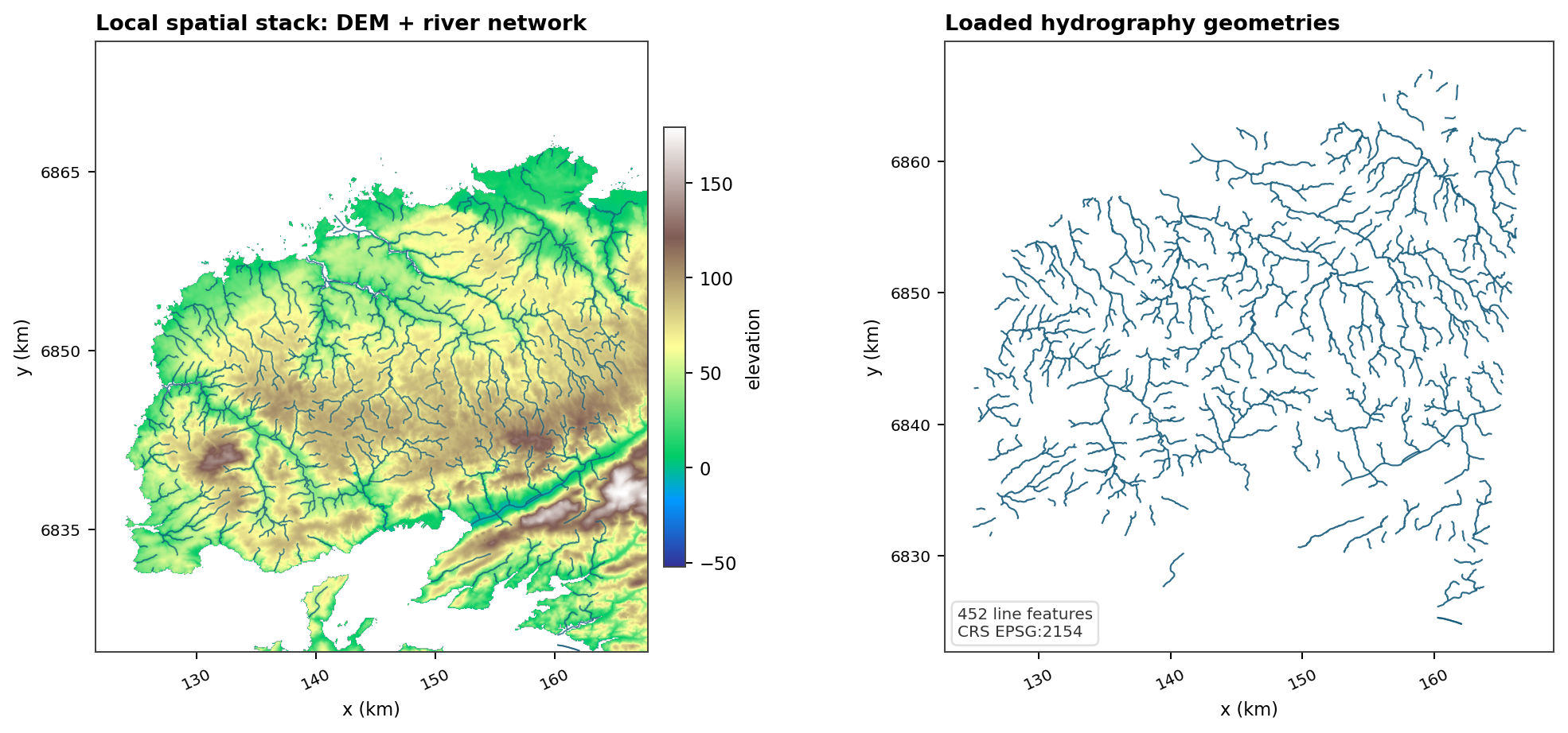
Fig. 140 This generated data-doc figure is smaller than the Nancon overview and focuses on one practical question: does the raster support align with a vector hydrography layer in the same projected CRS?#
Downstream uses#
watershed and study-area support;
terrain-derived masks and raster alignment;
mesh and overview context;
solver figures that display head or water-table depth against terrain.
DEM Source: custom#
Use source = "custom" for a project-owned elevation raster. This is the
right choice for production studies, offline tests, training material, or any
case where the DEM has already been curated outside HydroModPy.
Minimal example#
[[data.dem.sources]]
source = "custom"
path = "data/dem/local_dem.tif"
mask_path = "data/masks/watershed.gpkg"
Operational checks#
pathis resolved from the TOML file, with workspace data fallbacks for bare filenames.mask_pathcan clip or validate the target support.The raster must carry usable CRS and geotransform metadata.
Source units should be explicit if the file metadata are ambiguous.
Expected figure#
Open the DEM overview panel from the family page and confirm that local terrain and watershed support agree. A custom DEM should not require solver-side compensation.
DEM Source: ign_geoplateforme_dem#
Use source = "ign_geoplateforme_dem" when a workflow should resolve French
administrative regions or departments, discover matching IGN archives through
Geoplateforme, assemble the DEM, and cache the processed GeoTIFF.
This source lives in the data layer. Workflows such as site_selection only
declare their DEM need through [data.dem]; they do not call IGN services
directly.
Minimal example#
[data]
types = ["dem"]

[[data.dem.sources]]
source = "ign_geoplateforme_dem"
dataset = "bd-alti"
resolution_m = 25.0
file_format = "ASC"
regions = ["Auvergne-Rhone-Alpes"]
Operational checks#
regionsare canonical French region names such asBretagne,CorseorAuvergne-Rhone-Alpes. HydroModPy resolves the corresponding departments before download.departmentscan be used instead when the required support is known explicitly.The assembled product is currently BD ALTI 25 m ASC written as a clipped GeoTIFF in
data/dem/processed.The processed cache is keyed by bbox and departments and accompanied by a JSON metadata sidecar. Compatible processed rasters are reused without re-downloading raw archives.
RGE ALTI discovery/download is available for inspection through the helper, but assembled RGE ALTI rasters are intentionally not enabled yet. Large 1 m or 5 m regional requests need explicit storage and processing guardrails.
Cache layout#
The Geoplateforme source separates raw archives, extracted archive contents, and processed GeoTIFFs:
<workspace>/data/dem/
  raw_ign/
    bd-alti/25m/D029/*.7z
  extracted_ign/
    D029_<hash>/
  processed/
    dem_ign_geoplateforme_bdalti_25m_<hash>.tif
    dem_ign_geoplateforme_bdalti_25m_<hash>.json
For site_selection review maps, use BD ALTI 25 m as the default regional
background. Reference hydrography such as BD Topage may be used to constrain
outlet snapping, but it should not be displayed as a cartographic proof of the
selected basin network unless that is the explicit review objective.
French IGN archive helper#
tools/download_dem_fr is a standalone helper for preparing or diagnosing
French IGN DEM archives outside a full HydroModPy run. It is useful when a
regional workflow needs many departments, for example before producing a
regional review map.
The helper is intentionally separate from site_selection. Workflows should
still request DEM data through [data.dem]; the helper only manages raw
archive discovery/download.
By default, the helper writes raw IGN archives outside the source repository:
HYDROMODPY_WORKSPACE/data/dem/raw_ign when HYDROMODPY_WORKSPACE is
defined, otherwise ~/hydromodpy/data/dem/raw_ign. Use --output-dir only
when an explicit data cache location is needed.
Examples#
Dry-run BD ALTI 25 m for one department:
python tools/download_dem_fr/download_dem_fr.py \
  --departements 29 \
  --dataset bd-alti \
  --resolution 25 \
  --format ASC \
  --dry-run
Dry-run the Auvergne-Rhone-Alpes departments:
python tools/download_dem_fr/download_dem_fr.py \
  --regions Auvergne-Rhone-Alpes \
  --dataset bd-alti \
  --resolution 25 \
  --format ASC \
  --dry-run
Show provider checksums in a dry-run when Geoplateforme exposes them:
python tools/download_dem_fr/download_dem_fr.py \
  --departements 29 \
  --dataset bd-alti \
  --resolution 25 \
  --format ASC \
  --dry-run \
  --include-md5
Cache layout#
The helper stores raw archives by dataset, resolution, and department:
~/hydromodpy/data/dem/raw_ign/
  bd-alti/
    25m/
      D029/
        BDALTIV2_...D029....7z
For regional site_selection review maps, BD ALTI 25 m is the assembled DEM
source exposed by the data manager. RGE ALTI 5 m or 1 m is available only as
raw archive inspection/download through the helper until storage and assembly
guardrails are defined explicitly.